Current Projects
Stay informed about projects currently underway in the City of Albany. View the City at Work interactive mapping platform or browse current projects below.
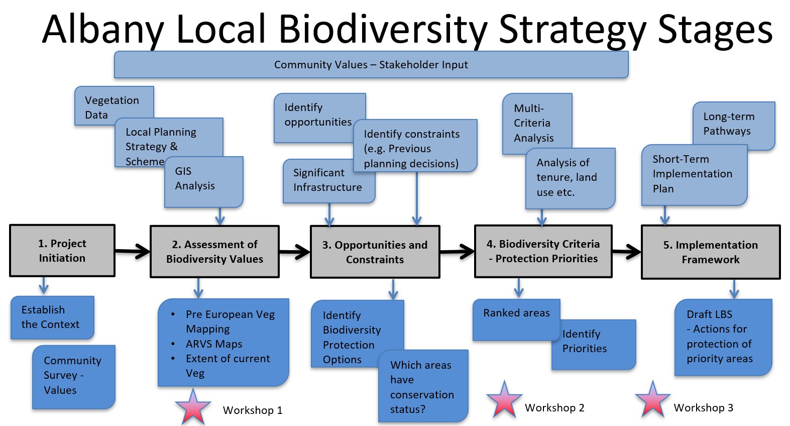
Albany Local Biodiversity Strategy
The City of Albany is developing a Biodiversity Strategy to facilitate the protection, enhancement and linkage of local natural areas. The strategy will assist the incorporation of biodiversity considerations into planning and decision-making processes which are under the control of the City of Albany. This will support the protection of the natural environment and maintain a high diversity of flora and fauna in the municipality.
Progress Report - updated February 2025
Stakeholder engagement to date has included a survey (determine values) and two workshops.
The initial survey confirmed strong desire amongst respondents for better protection/management of native bushland and biodiversity features within the municipality.
Workshop 1 identified key criteria in prioritising areas of local natural value:
- Connectivity, including vegetation, wetlands, streamlines, estuarine and coastal areas
- Rarity
- Vegetation Condition
- Areas of recognised international, national or regional value
- Representation
- Regional holistic approach to reduce threats
- Diversity related criteria including migratory birds, visitor bird hot spots and nomad birds
- Size of patch
During Workshop 2 it was agreed that the strategy vision needed to be succinct and describe expectations for biodiversity.
The following draft vision is proposed which can be reviewed as part of the advertising process, if necessary:
“Caring for Country – Kinjarling/Albany - where nature can thrive and adapt”
At Workshop 2, we identified opportunities and constraints for biodiversity protection/management.
Opportunities to biodiversity protection/management include:
- 8% vegetation remaining
- Significant areas protected in reserves
- State controls for vegetation clearing
- Support for volunteers
- Forming partnerships and collaborations
- Road reserves as corridors
Constraints to biodiversity protection/management include:
- Land clearing, degradation and fragmentation
- Lack of resources (personnel, funding)
- Competing objectives (growth of Albany population, fire risk regulations, approved development, minor clearing)
- Threats (weeds, disease, pests)
- Climate change (poorly known interactions and outcomes)
- Gaps in knowledge
- Threatened species on private land or unsurveyed areas
- What are the keys to adaptation at the landscape scale
- Use of non native habitat (blue gum plantations, pines, weeds, drains)
- Use of road reserves
Consultation to date has confirmed the high level of importance, to protecting our natural areas, regardless of the extent of attributes such as size and condition.
So, all our natural areas should be considered as worthy of protection.
The strategy proposes to use a scoring matrix to determine the level of action required for protection of biodiversity values, based on extent of native vegetation and other data sets available for Albany.
By using key criteria (e.g. vegetation connectivity, representation, condition, support of threatened species and communities etc.) and factoring in opportunities and constraints, we can nominate priority areas for action.
However, we are still working on details for this.
The City proposes to develop a public mapping tool, which will overlay key criteria related to biodiversity and identify actions for biodiversity preservation and enhancement. We propose to bring the mapping and prioritising tools to a future Workshop 3 for discussion.
The below provides a staging plan for the development of the strategy.
1. Study Area
The project area for the Local Biodiversity Strategy encompasses the entire municipality of the City of Albany. The focus will be on areas which do not already have conservation protection (i.e. not National Parks and Nature Reserves). However, all natural areas will be considered in the context of biodiversity, linkage and overall values.
2. Project Scope
The strategy development is guided by 'An Introduction to Local Biodiversity Planning for Local Government in the South-west of Western Australia' (Western Australian Local Government Association, 2023).
WALGA LBP Overview 2023
Activities will include:
- Identification and assessment of biodiversity values for Local Natural Areas.
- Establish criteria and a priority framework for areas of high conservation value.
- Identification of opportunities and constraints to biodiversity protection.
- Identify ways to achieve local biodiversity conservation.
- Identify conservation objectives and targets.
- Prepare draft local biodiversity strategy for public input.
- Prepare final version of the local biodiversity strategy for adoption by Albany City Council.
3. Community Stakeholder Group
The City has invited representatives from the following organisations to form a Community Stakeholder Group to provide diverse perspectives, local insights and technical input throughout the strategy development process.
- Wagyl Kaip Southern Noongar Aboriginal Corporation;
- Wildflower Society (Albany);
- Birdlife WA;
- Torbay Catchment Group;
- Oyster Harbour Catchment Group;
- Wilson Inlet Catchment Committee;
- Friends of Yakamia Forest;
- UWA;
- Gondwana Link;
- South Coast Natural Resource Management Inc.;
- Department of Biodiversity, Conservation and Attractions;
- Department of Water and Environmental Regulation;
- Department of Planning, Lands and Heritage;
- Western Australian Local Government Association; and
- Individuals with an interest in local biodiversity.
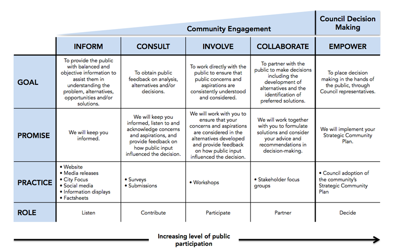
4. Community and stakeholder engagement
The project includes a stakeholder engagement plan, which seeks to:
- Establish engagement objectives;
- Identify key stakeholders;
- Outline types and level of engagement; and
- Detail the actions proposed over the project timeframe.
Link to adopted stakeholder engagement plan.
Engagement Plan
A community survey has been undertaken to determine community sentiment about biodiversity protection.
Key findings included:
|
Survey Effort
|
- The high number of responses received (693), and effort taken to complete the survey signify that Biodiversity and Urban Forest are important community issues.
- Responses received from 42 localities within the City of Albany, with 84% stating that they lived in urban Albany.
|
|
Biodiversity Conservation
|
- 93% of respondents feel that biodiversity conservation in the City of Albany is Important to Very Important
- There was a strong desire amongst respondents for better protections on native bushland with the municipality.
|
|
Biodiversity Loss
|
- 96% of respondents are concerned about biodiversity loss within the City of Albany
- 56.7% of respondents believe that biodiversity is Declining or Declining Significantly in the City of Albany
- The highest perceived threats by respondents were:
o Clearing for land subdivision
o Non-native animals (feral cats, foxes, rabbits)
o Weeds
o Dieback
o Tree canopy loss
o Climate change impacts
- Uncontrolled pet cats was also a concern for multiple respondents in the open-ended response.
|
|
Biodiversity Values
|
- The highest ranked values for biodiversity were:
o To preserve the biodiversity of life and ecosystem processes
o Living close to nature
o The role biodiversity plays in mitigating climate change
- Respondents recognise the value of native vegetation for preserving and enhancing corridors or wildlife and protecting plants, animals and other organisms.
- Respondents value the location of native vegetation for enhancing biodiversity values.
|
|
Actions by the City of Albany
|
- Strong support for more action by the City of Albany to protect biodiversity.
- In general, there was slightly higher support for direct actions such as managing weeds and pests and slightly less support for changes to policy and community education. The exception was for the Council to consider nature and biodiversity in all decision making. 85% of respondents believed this was Very Important which was the highest ranked action.
- Concerns included:
o The council would take away rights of property owners to manage vegetation on their private property.
o Biodiversity values would take precedence over bushfire management and safety.
|
Community survey results
5. Assessment of Biodiversity
A desktop assessment and GIS modelling will be undertaken to identify biodiversity values of existing local natural areas across the municipality
A review of existing data will allow for information to be considered in the framework of current legislation, identify gaps in knowledge, and identify opportunities and constraints.
6. Opportunities and constraints to biodiversity conservation
The assessment of biodiversity values will be in collaboration with a Steering Committee and the Community Stakeholder Group.
The Strategy will concentrate on matters where the City of Albany has planning control, with a focus on natural areas with a low level of protection. Special attention will be given to areas identified in the current Albany local planning strategies and schemes for future development and areas identified for recreation and tourism. Some key considerations for the assessment may include:
- Potential for conflicts and impacts associated with surrounding land uses by reviewing:
- Local and State Planning Schemes and Policies
- Proximity to sensitive land uses, environmentally sensitive areas and buffer zones
- Identifying key physical characteristics such as:
- Geology, geomorphology/landform and soils
- Wetlands and other surface water features (if any present)
- Habitat/native vegetation connectivity and linkage throughout the municipality
- Describing biological values (flora and fauna) and other sensitive areas including:
- Vegetation/flora/fauna habitat present
- Potential conservation significant flora, fauna and vegetation (Threatened Ecological Communities)
- Bushfire risk
- Heritage values including Aboriginal and European Heritage
7. Establish criteria and a priority framework for the identification of areas of high conservation value
In collaboration with the Community and Stakeholder Group, criteria will be established to determine the value of local natural areas as high, medium or low conservation value.
A framework will be established to assign priority levels for areas identified as high conservation value and potential protection and management opportunities for these areas will be identified.
8. Draft Local Biodiversity Strategy
The findings and recommendations will be used to develop the draft Local Biodiversity Strategy in accordance with WALGA Guidelines. This will be in collaboration with a Project Steering Committee.
The draft Local Biodiversity Strategy will be presented to the Community Stakeholder Group and Elected members through workshops and formal advertising of the draft strategy (including public information sessions).
Link to Draft Local Biodiversity Strategy...not yet available
9. Final Local Biodiversity Strategy
Based on the submissions and comments received when the draft local biodiversity strategy is
presented and advertised, a Final Version of the Strategy will be developed.
This will be prepared in consultation with the Steering Committee and will reflect modifications based on submissions.
Once the final Local Biodiversity Strategy has been prepared, information will be presented in a workshop to the Elected Members. This will aim to seek support for the final draft strategy and progress to formal adoption of the Local Biodiversity Strategy by the Council.
Link to Final Local Biodiversity Strategy...not yet available
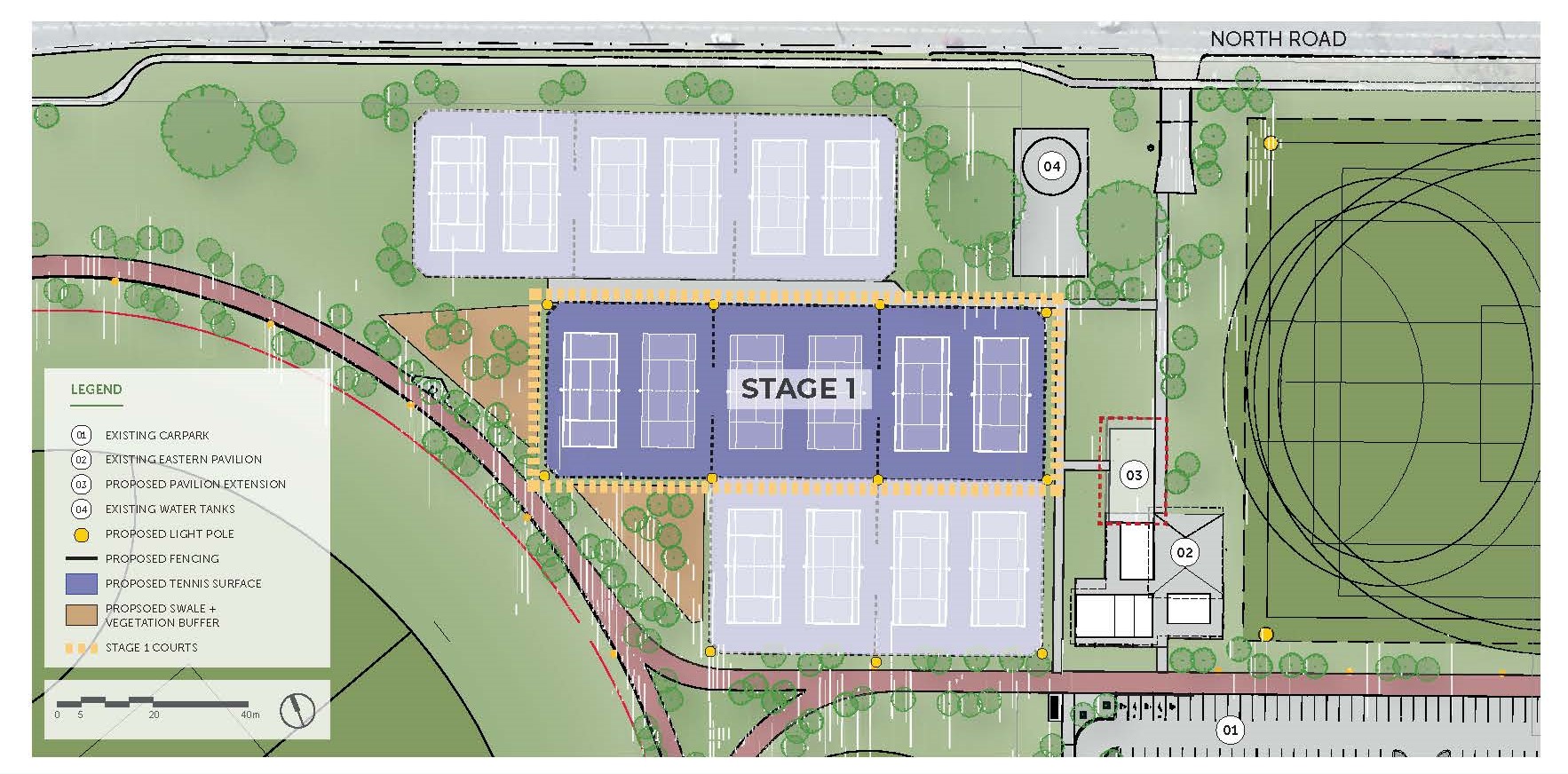
Albany Regional Tennis Centre - Stage 1
BACKGROUND
The delivery of Albany Regional Tennis Centre will see Merrifield Park Tennis Club and Lawley Park Tennis Club amalgamate to form the Albany Tennis Club.
The overarching purpose of the project is to develop a 16-court regional tennis centre, as a multi-stage project in the Eastern Precinct of the Centennial Park Sporting complex.
Stage 1 will involve the construction of 6 courts and the implementation of a court booking system.
Should future funding allow, additional stages will include: an additional 10 tennis courts, flood lighting and extension to the existing shared clubroom facilities.
OBJECTIVES
The main project objectives are:
- Increased participation in tennis with new local and state event opportunities.
- Encouraging social and sporting club growth to further develop local community spirit, pride, participation, and activity.
- Complement and build on the recently completed and well-developed sporting infrastructure throughout the Centennial Park Precinct.
SCOPE
Stage 1 will involve:
- Construction of 6 x ITF minimum standard Tennis Courts.
- A book-a-court system (enabling the community to book courts via a mobile application at any time.
- Associated infrastructure including fencing, poles, nets etc.
- Storm water and drainage works.
FUNDING
The total project value is $1.325M and has been funded from the following organisations:
- Department of Local Government, Sport and Cultural Industries
- Great Southern Development Commission
- City of Albany
- Tennis Australia
TIMING
Construction commenced in February 2024 and is expected to be open for bookings in January 2025
The courts will be able to be booked through the Albany Tennis Club.
Project Information Board _ Albany Regional Tennis Centre - Stage 1
Youth Challenge Park - Multi-Use Court
Youth Challenge Park (Centennial Park Youth Precinct) seeks to create an intergenerational community activity hub connected to the wider Centennial Precinct, focused on unstructured and accessible recreation types. Following completion and opening of Challenge Park to the public in 2021, a funding strategy was identified for the last remaining phase of the project – the Multi Use Court – involving municipal and state funding sources.
The creation of a high quality environment that will encourage and support youth focused and youth-friendly year round seasonal programs and events that celebrate diversity, identity and self-expression and encourage connectivity. The multi-use court will be the only outdoor, full size basketball court in Albany freely accessible for the community, and will breakdown barriers of affordability and provide disadvantaged youth with a space they can participate and engage in positive sporting activities.
Construction has commenced and is expected to be completed by May 2025
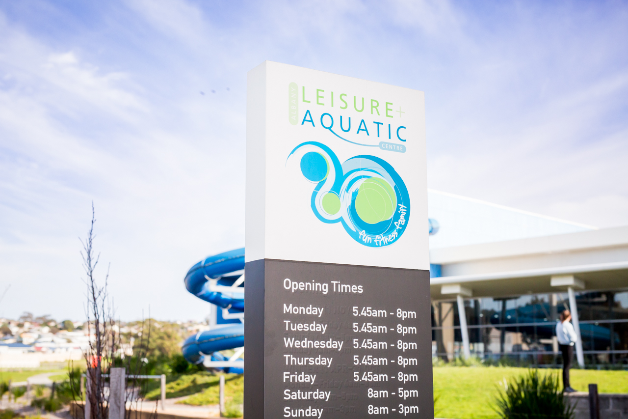
Albany Leisure and Aquatic Centre Feasibility Study
The City of Albany is undertaking a feasibility study into Albany Leisure and Aquatic Centre (ALAC) and is seeking community feedback from users, spectators, parents, and community groups from across the region.
The study by Otium Planning Group will assess current and future demand on ALAC and whether the current level of service is sufficient to meet user needs and expectations.
Featuring a pool, gym, indoor courts, creche and café, ALAC is the City’s busiest community facility with more than 500,000 visits annually and is an important community hub for leisure, health, recreation and networking.
A survey is being conducted as part of the study, inviting everyone who has an interest in ALAC to share their views and help guide the study’s recommendations.
This survey will be open until 2 August 2023. To complete the survey, please click the link below:
ALAC Feasibility Survey
Click here to read the media release.
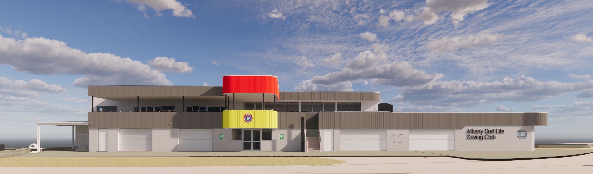
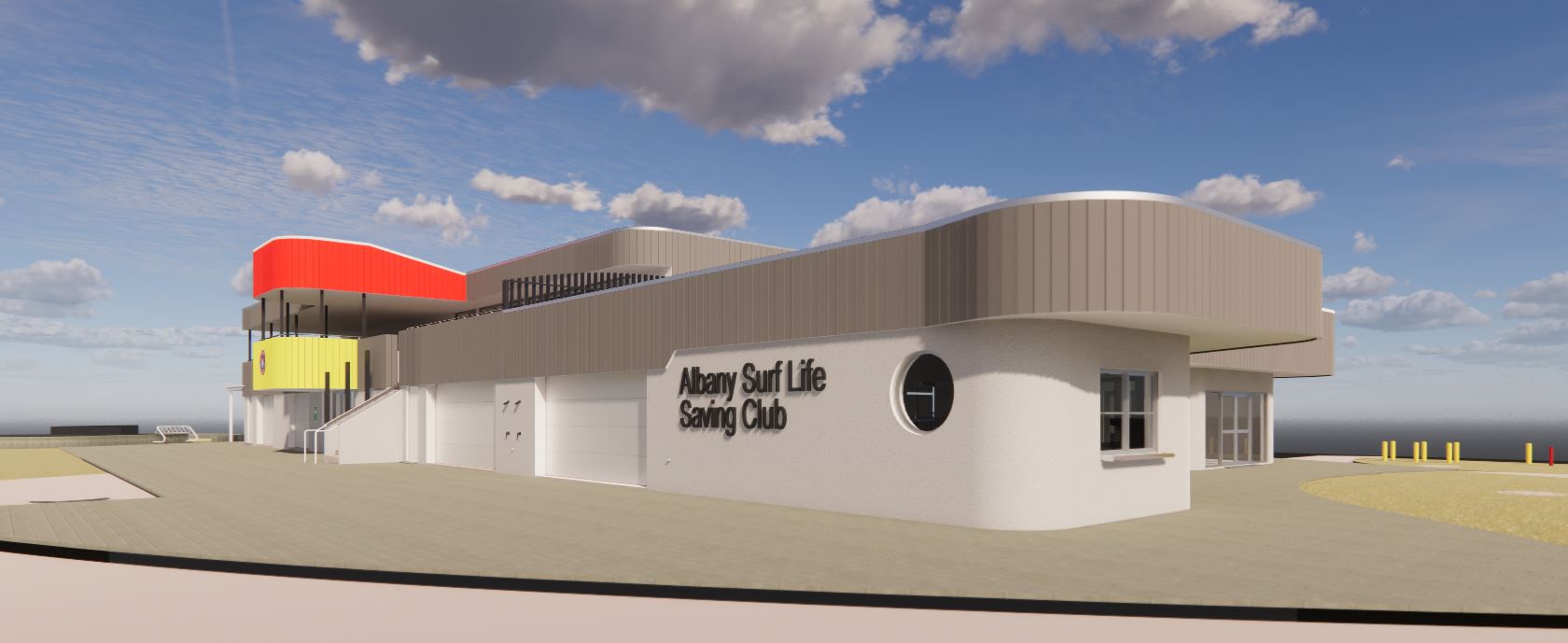
Albany Surf Life Saving Club Redevelopment
BACKGROUND
ASLSC provides a highly valued community service for Albany and the Great Southern in the delivery of lifesaving, emergency response, first aid, training and education, and intergenerational sport, recreation, and community events.
In response to the recent infrastructure upgrades within the Middleton Beach Precinct and growing memberships, ASLSC undertook a review of its strategic vision to address several pressing challenges and opportunities affecting its future.
The expansion and redevelopment of the existing club house was identified as a key project to be delivered as part of the ASLSC Strategic Plan to provide:
- A safer, more efficient, and welcoming community facility:
- Improved lifesaving and water safety operations; and
- Increased community engagement through new training and education spaces.
OBJECTIVES
The main project objectives are:
- To address key safety risks related to the access and storage of motorised water safety equipment,
- To improve the safety, capacity and efficiency of core delivery areas – lifesaving, emergency services, training and education, surf sports and competition, community capacity building;
- To increase community benefit – improving the quality, capacity and accessibility of community facilities and services; and
- To assist City of Albany meet growing community demand at Middleton Beach and support the Foreshore and Activity Centre redevelopment goals and community strategic plans.
SCOPE
The scope of work comprises of:
- The expansion and separation of motorised water safety equipment and surf sports equipment.
- A centralised and dedicated life saving hub
- A new community meeting spaces to support community events and meeting activities. It is envisaged that community groups will be able to book this space at minimal cost – as opposed to booking the whole venue.
The Middleton Beach Public Toilets & Changerooms are located next to the ASLSC building, and do not form part of this project’s scope. There is currently a project underway to refurbish the Middleton Beach Public Toilets & Changerooms. Click here to find out more.
FUNDING
- WA Govt - DLGSCI
- Lotterywest
- City of Albany
- Albany Surf Lifesaving Club
TIMING
Construction is expected to commence in February 2024 with completion expected to be towards to end of 2024. During construction, the ASLSC building will not be available for use by community user groups. The adjacent public toilets and footpaths may also be unavailable for a short period of time during construction. Temporary facilities will be provided. The community be regularly updated with progress and disruption notices during construction period.
Albany Surf Life Saving Club Redevelopment Project Profile
Concept Only H+H Architects
Emu Point Sand Nourishment
OBJECTIVE
Coastal dunes from Middleton to Emu Beach provide both natural coastal defence against erosion and an environmental habitat. Short term work (sand nourishment or beach scraping) is an opportunity to rapidly improve beach amenity and the erosion buffers at Emu Beach whilst longer term solutions continue to be considered by the City.
SCOPE
To replace material that erodes from the dunes at Emu Beach each year. Waves, tides and storms erode the dunes and transport the eroded sand westwards along the beach. Eroded material is recovered seasonally from a wide area of the beach, generally below high tide, and transported back to the eroded area.
- The longer-term erosion rates have been around 3,000 cum/yr in this general area.
- In the order of 4,000cum was placed in the dunes pre-winter sand nourishment based on Contractors estimates. Survey analysis suggests in the order of 3,400cum of material was placed ( insitue surveyed volume), which is reasonable consistent with the measured bulk volume of 4,000m3 (i.e. typically ~ 20% bulking).
- Survey analysis and site inspections suggests most of this material eroded during the winter, helping to prevent further erosion of the ’natural dune’ back towards the path.
- There is estimated to be in the order of 1,000m3 of material remaining. All material placed in the corner had eroded.
- The spring nourishment design will aim to provide a similar buffer, focusing on placing sand across the beach profile, which will be feasible during low tides.
BENEFITS
- Rapid implementation and flexibility (with timing, volumes and cost)
- Manage erosion at its current location and mitigate downdrift impacts
- Built in resilience to coastal storm events
- Guided by science – tracked using high resolution surveys
- Improved beach amenity
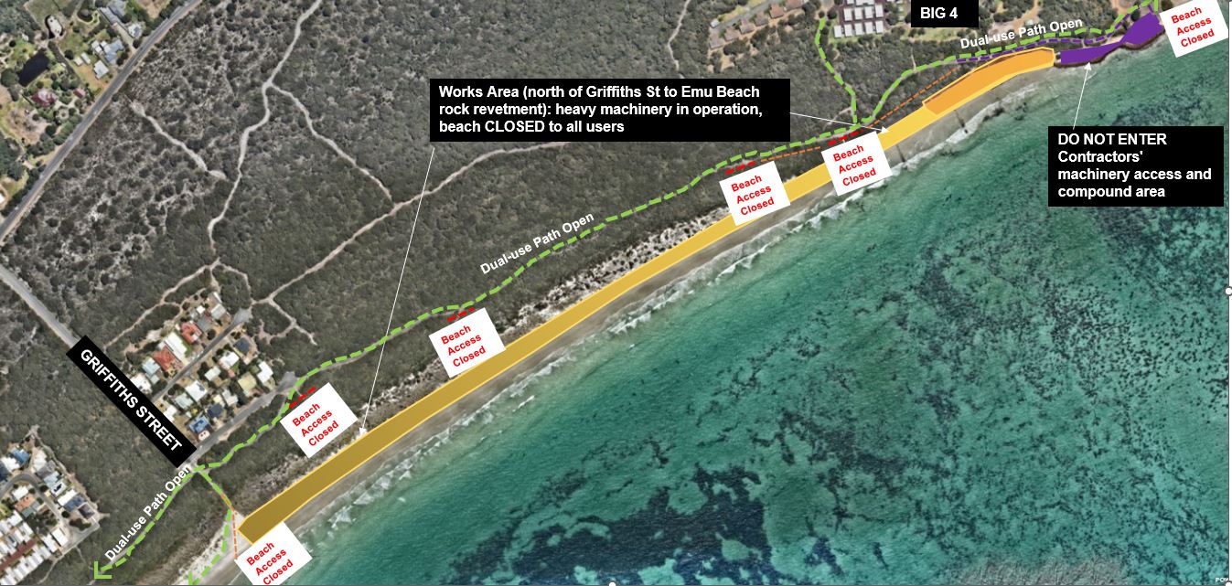
SAND NOURISHMENT MAY 2025
The City of Albany advises that Sand Nourishment works have commenced at Emu Beach near the corner of Firth Street and Boongarie Street. These works aim to improve beach amenity and resilience to storm events.
The City of Albany will endeavour to keep access restrictions to a minimum, but these works will require beach access to be closed between Griffiths Street to Emu Point. The dual-use path from Middleton Beach to Emu Point will remain open.
Please take care in the area.
The civil works begin on Tuesday 20 May 2025. It is expected that this section of beach will be closed until COB Friday 23 May 2025.
City of Albany Photo Beach Monitoring
The Emu Point to Middleton Beach Photo Monitoring Program was developed in 2014 as part of the Emu Point to Middleton Beach Coastal Adaptation and Protection Strategy. This strategy covers the coastal system that includes Oyster Harbour, Emu Point and Middleton Beach. The development of the Strategy was important to gain community input; assess all previous studies; identify gaps in the data and fill them; understand the values and essential character of the coastal region; and to identify viable management options for short and long term. The Emu Point to Middleton Beach Photo Monitoring Program is designed as a simple, inexpensive, scientifically valid, long range data gathering exercise, easily learned and maintained, easily expanded or contained, and engaging interested community members as volunteers. Outcomes of the program include:
-
Contribute to a detailed database of coastline change for the area of coast from Ellen Cove (Middleton Beach) to the Emu Point Boat Pens;
-
Collect data that will inform present and future management decisions for this area of coast;
-
Provide data in an easily usable, retrievable and compatible form for local, regional, state and national data gathering;
-
Begin a historical process that can be taught to and handed on to future generations; and provide a model of data collection that can be applied to other areas of coastline.
View the data here: Emu Point to Ellen Cove Beach Monitoring
Middleton Beach Activity Centre
Information on the DevelopmentWA Activity Centre
Progress continues with civil works, with the next phase to include subdivision and public infrastructure.
More Information
Southern Ocean Surf Reef (SOSR)
The Albany community have been advocating for an artificial surf reef for nearly two decades. Prior to City involvement, a series of comprehensive reports were undertaken by advocacy groups in relation to the creation of an artificial surf reef in Albany.
A Steering Group was established by the City who commissioned an updated Feasibility Study for an artificial surf reef at Middleton Beach. The study was completed in July 2015 DHV with the primary objective being to deliver:
“The creation of a consistent, surfable wave, which maximises available swell conditions and is central to Albany, driving benefits in tourism, economic development and retention of Albany’s younger age demographic
Southern Ocean Surf Reef Community Update & FAQs
City of Albany Artificial Surf Reef Feasibility Survey Results 2016
Albany Artificial Surf Reef Executive Summary Detailed Design
Albany Artificial Surf Reef Executive Business Case 2020
Business Case Summary
Cost Benefit Analysis:The costs in the analysis include the capital costs for the project, phased in line with the plan. Benefits explored in the analysis include:
- An uplift in event visitation associated with committed Albany Boardrider and Surfing WA events (~10 per annum);
- An uplift in overnight tourism, a conservative estimate of around 3,500 people per annum
- Indirect visitor spend benefits through the ‘ripple’ effect.
- The calculations demonstrate a positive Net Present Value (NPV) of $57.9 million and
- Benefit-Cost Ratio (BCR) of 6.69.The results remain strong even if only event benefits are calculated, without visitor uplift.
Tourism Benefits:
- Hosting surfing events to increase tourism.
- Drawcard as a tourist destination - general uplift in visitation and length of stay expected.
- Complementing Investment:
- Supporting Albany's position as the Adventure Capital of Western Australia.
- Enhancing private and public developments from Emu Point to Middleton Beach.
- Boosting the Middleton Beach Activity Centre and recently completed foreshore enhancements.
- Long-term sustainable infrastructure investment that will benefit the environment.
Demographic and Educational Benefits:
- Attract and retain the younger demographic.
- Aligning with tertiary educational opportunities, especially at UWA Albany and student housing, including marine science and ecological courses.
Healthy, Active Benefits:
- Establishing Albany as a recognized outdoor recreation and surfing hub.
- Substantial economic and social benefits from increased participation.
- Improved safety through increased monitoring and less travel.
Albany Artificial Surf Reef Video With Subtitles
Albany Artificial Surf Reef Video - No Subtitles
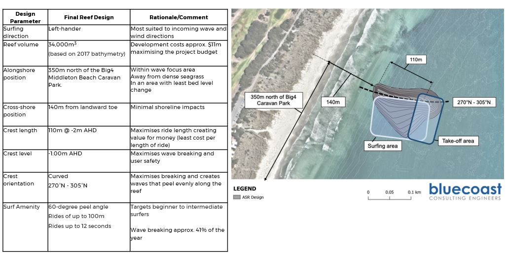
Design Aspects:
The detailed design outcomes concluded that:
- The proposed SOSR will consist of a submerged rock reef structure, the design of which has resulted from an iterative process involving thorough numerical, physical and conceptual modelling.
- All aspects of the SOSR design were considered in modelling, including its location, footprint and shape.
- The location has been optimised based on existing seabed variability, user accessibility, shoreline response, wave climate and local ecology.
- The shape has been optimised to improve wave breaking characteristics, promote user safety, minimise coastal impacts and reduce construction costs.
- The design provides a ‘left-hander’ surfing wave, situated 150m north of the ‘Surfer’s Beach’ car park and approximately 140m offshore. The reef measures 165m long and varies in width up to 110m. At its shallowest point, the crest of the reef will be 1m below average water level to maximise wave breaking whilst also ensuring adequate user safety.
- The design provides surfing rides of up to 100m during average conditions, with surfable waves expected for 41 per cent of the year over the reef, with further surfing opportunities inshore of the structure.
- The reef is made up of layered rock structure comprising quarry run belly, core rock layer and protective armour rock (sizes as shown below)
- The SOSR has a relatively large footprint with mild seaward slopes and a broad 3D shape.
- Shallowest crest level of -1.0m AHD which is approximately 0.74m below mean low water (MLLW) and 1.34m below mean high water (MHHW).
- The rock structure is to be constructed to relatively tight tolerances, which vary across the structure’s footprint as outlined below.
- The structure is designed to be low maintenance (with physical modelling tests simulating storm event conditions to prove structure stability and performance), with low maintenance requirements associated with inspection and monitoring.
Reef Volume
62,800 t
Belly D50 0.16m 12,400 t (18%)
Core D50 0.49m 23,600 t (36%)
Class 1 Armour D50 0.94m 26,800 t (46%)
Project Team
Project Principal: City of Albany
Main Contractor: Heron Construction Limited
Design Consultants: Bluecoast Consulting Engineers
Project Superintendent: Stantec
PROGRAMME:
Quarry site establishment and rock production
Spinifex Crushing and Screening Services (Martin Shuttleworth) Mindijup Rd. Palmdale
Oct 24 – Feb 25
Status: 30% complete
Delivery of rock from quarry to port
Jan 25 – Feb 25
Status: first delivery expected mid-Jan
Establishment of Material Loading Facility (MLF) at Port
Dec 24- Jan 25
Status: awaiting approval from Southern Ports
Marine plant mobilisation (from Darwin)
Nov 24
Heron’s Machiavalli backhoe dredge has arrived early from Darwin and currently secured and parked in Berth 4 at the Port. This is the main plant that will be used to construct the actual reef in March 2025.
Marine plant mobilisation (from Adelaide)
Jan 25
This will include a Messenger flat topped spudded barge (for mooring at the MLF), split hopper barges, material handling machine, towing tugs and survey craft
Construction period (loading of rock onto barges and placement onto seabed floor)
Jan – Mar 25
Surveys and practical completion
Mar 25
Funding Sponsors:
Total Committed Funds: $ 11,750,000
Commonwealth Govt.: $ 5 million
WA State Govt (DPIRD).: $ 4.75 million
City of Albany: $ 1.995 million
Albany Boardriders: $ 5,000
Albany Motorsport Park
Down Road, Drome
Project Outcomes
The development of a family friendly, affordable and sustainable multi-use motor sport park for the Great Southern Region, that will accommodate most motorsport disciplines and compatible sports, maximising the commercial benefits of shared facilities.
Albany has a rich history in motorsport dating back to the 1930’s. This project provides an appropriate recreational facility to cater for the current and future growth of motorsport in the Great Southern.
Motorsport in Albany & the surrounding areas is already known to be popular, with several well organised clubs, a national-level venue for speedway, a state-level venue for go-karts and widely recognised events such as the Albany Classic, Show ‘n Shine and Targa Albany Sprint. Some motorsport disciplines particularly motorcycle racing and motocross lack suitable regional facilities. The concept of the Albany Motorsport Park has been designed with flexibility for a variety of user groups and specifically to meet current and future safety requirements for motorcar and motorcycle racing and other compatible sports, like cycling.
Albany Motorsport Venue Inc. (AMV) are the operating body of the venue, future events and programming will be advertised and updated through the AMV website. https://albanymotorsportpark.com.au/index.html
PROJECT PROFILE
COMMUNITY UPDATE
SURVEY - ALBANY MOTORSPORT PARK
The City of Albany conducted a survey on behalf of the operator, Albany Motorsport Venue Inc in relation to the new Albany Motorsport Park development in October 2024
Results can be found here:
Albany Motorsport Park Survey Report
Survey winner was randomly drawn - winner 369 chose to receive a voucher from Totally Sports & Surf
NOISE MANAGEMENT PLAN (NMP) – ALBANY MOTORSPORT PARK, DOWN ROAD, DROME – COMMENT PERIOD CLOSED
The City of Albany invited stakeholder and community feedback on the draft Noise Management Plan (NMP) for the Albany Motorsport Park on Down Road, Drome.
The Albany Motorsport Park vision is the ‘development of a family friendly, affordable and sustainable multi-use motor sport park for the Great Southern Region; providing a shared home for a range of motorsport disciplines, driver education, compatible sports and events, maximising commercial benefits of shared facilities.’
The Noise Management Plan considered the impact of the use of the Albany Motorsport Park on the surrounding area and presented management methods to limit and control noise emissions. It also detailed the actions required to be implemented by the AMV prior to and during use of the facility to minimise the noise impact on the surrounding area.
The proposed Noise Management Plan was made available for public comment in accordance with the Local Government Act 1995. The comment period is now closed.
Princess Royal Harbour Coastal Hazard Risk Management Adaptation Plan (CHRMAP)
The City of Albany in conjunction with the Community, the State Government and Southern Ports, has developed a DRAFT Coastal Hazard Risk Management Adaptation Plan (CHRMAP).
The DRAFT CHRMAP has been developed to increase knowledge and understanding of coastal hazard risks pertaining to the Princess Royal Harbour and to identify risk management and adaptation measures for implementation.
The DRAFT CHRMAP is being displayed in two formats:
- Summary CHRMAP document for advertising purposes
- Technical CHRMAP
Summary CHRMAP document
A summary CHRMAP document has been developed for advertising purposes.
This summary document seeks to increase knowledge and understanding of coastal hazard risks pertaining to the Princess Royal Harbour and to identify risk management and adaptation measures for implementation. The draft recommendations for managing coastal processes associated with the Princess Royal Harbour into the future include:
- Protecting potential erosion areas via sand nourishment.
- Protecting potential inundation areas via the development of levees.
This summary document includes a proposed funding mechanism for proposed protection works. The funding mechanism works off a beneficiary pays principle. Beneficiaries are likely to include:
- State Government
- Business and Industry
- Private landholders
- Local community
- Broader community
The summary CHRMAP document is located here....not yet completed
DRAFT Technical CHRMAP and background reports
The DRAFT Technical CHRMAP document and background reports are located below....click on green tabs.
Note: the DRAFT Technical CHRMAP is to be updated to identify how funding for any coastal protection works should be organised.
The development of the CHRMAP adheres to the Western Australian Planning Commission (2019) CHRMAP guidelines with scope and deliverables consistent with their objectives and the State Planning Policy 2.6 – Coastal Planning (SPP2.6).
The CHRMAP area was broken into five (5) Management Unit (MU) areas. Assessment and recommendations were made for each MU area. Detailed implementation recommendations for each MU are presented at Table 8-5 of the Technical CHRMAP.
Engagement Plan
Establish the Content
Risk Identification
Vulnerability Assessment
Advertising/Submissions
The City is undertaken the following advertising measures:
- Notification on the City’s website
- Documentation available at the City’s administration building
- Notice published in the local newspaper
- Letter to agencies, key stakeholders and landholders
- Comments via an online submission tool
Submissions on the CHRMAP and including funding mechanism, may be lodged via the online submission form (see link below) before the Yet to be confirmed (date) and must include:
- Email
- The name and address of the person making the submission
- Details of the submission
To complete the online submission form, click on the link below:
Yet to be completed
To ensure concerns and aspirations are understood and considered, City of Albany Officers are available to explain the CHRMAP and to answer questions (phone 68203050, Email [email protected]).
Policy and Guidelines
The CHRMAP has been prepared in accordance with the WA Coastal Zone Strategy, the State Planning Policy 2.6 – State Coastal Planning Policy (SPP2.6) and the CHRMAP Guidelines.
Details on the strategic and policy intent can be found at the following links.
https://www.wa.gov.au/system/files/2021-07/CST-WA_Coastal_Zone_Strategy.pdf
https://www.wa.gov.au/system/files/2021-07/SPP-CST-SPP2-6_Policy.pdf
https://www.wa.gov.au/system/files/2021-07/GD_CST_coastal_hazard_risk_management-guidelines-July2019.pdf
Albany Heritage Park Link Trails Project
The Albany Heritage Park Link Trails Project involves the rationalisation of the existing trails network at Mt Adelaide (Irrerup) and Mt Clarence (Corndarup). This initiative includes the closure and revegetation of approximately 1 hectare of unsanctioned trails, alongside the construction of new trails built to best-practice standards. The completed network will feature 8 km of single-use walking trails, 10 km of family-friendly mountain bike trails, and nearly 5 km of dual-use pathways for both pedestrians and cyclists.
State and Federal government clearing permits for construction of the trails were finalised in December 2024. The approval process spanned several years, with a considerable history of specialist assessments informing the revision of the trails footprint to minimise environmental impacts. The permit conditions also ensure the protection of 22 hectares of land within the Albany Heritage Park area as an offset for any residual environmental impacts.
More information on the AHP Offset Strategy can be found here: Offset Strategy
The project has now advanced to the procurement phase with the City currently preparing Tender documentation for the construction of the trails.