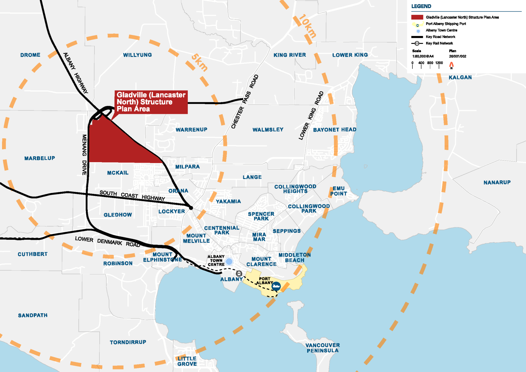
Gladville (Lancaster North) Project
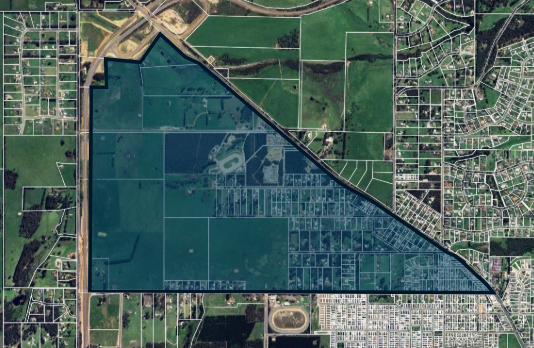
The City of Albany is preparing the Gladville (Lancaster North) Structure Plan for land north of Lancaster Road in McKail.
The project will guide future development of the area, including housing, roads, parks, community facilities, schools, shops and infrastructure.
The Structure Plan is being prepared alongside a Development Contribution Plan and Local Planning Scheme Amendment to support coordinated future development across the precinct.
What area does the project cover?
The project area is located in northern McKail, generally bounded by Lancaster Road, Albany Highway and Menang Drive (Albany Ring Road), near Albany Regional Airport.
The area currently includes a mix of rural, semi-rural and agricultural land, together with recreation and infrastructure uses including Attwell Park Speedway and the South Coast Country Music Club.
This area is referred to as the Gladville (Lancaster North) precinct.
Why is the project being undertaken?
This project is an important opportunity to help meet the needs of Albany’s growing population while planning responsibly for the long term. The Gladville precinct has been identified as an important future urban growth area within Albany’s northern growth corridor.
Planning for the site now can help provide:
- More homes for future families
- Parks and recreational spaces for everyone to enjoy
- Shops and community services close to where people live
- Protection of important natural areas and environmental values
- Roads and services planned and delivered in a coordinated way
- A well-designed community for future generations
The project will help ensure future development is planned in a coordinated way, with housing, infrastructure, transport, parks, shops and community facilities considered together. This approach helps create connected, liveable and well-planned communities.
The Structure Plan will establish a framework to guide future subdivision and development over time, while responding to the site’s environmental, servicing and infrastructure considerations, together with the community’s values, needs and aspirations.
What will the Structure Plan consider?
The Structure Plan will investigate and plan for:
- housing and neighbourhoods
- roads, walking and cycling connections
- community facilities and services
- schools
- parks and recreation
- shops and local services
- environmental and bushfire matters
- servicing and infrastructure requirements
- staging and coordination of future development
Community and Stakeholder Engagement
Community and stakeholder engagement will form an important part of the project.
The City and project team will engage with residents, landowners, businesses, government agencies, Traditional Owners, and the broader interested community throughout the planning process.
Opportunities to get involved may include:
- Workshops and stakeholder meetings
- Surveys and feedback opportunities
- Community information sessions
- Public advertising of draft documents
Project Outcomes
The project will deliver three outputs:
- Structure Plan – a document that will guide how the project area is used and developed over time.
- Development Contribution Plan – a document that will coordinate the delivery of infrastructure and fairly share the costs between those benefitting from this infrastructure.
- Local Planning Scheme Amendment – to update the zoning and support the implementation of the Structure Plan and Development Contribution Plan
Together, these documents will guide future development and infrastructure delivery within the project area.
Project Timing
The project is currently in the investigation and early planning phase.
Technical investigations, engagement and preparation of the draft planning framework will continue throughout 2026.
Public advertising of the draft Structure Plan, Development Contribution Plan and Local Planning Scheme Amendment is currently anticipated in late 2026 (October–December), subject to project progress and statutory requirements.
The planning process is expected to continue into 2027.
Stay Informed
Project updates, engagement opportunities and key documents will be published on the City of Albany website as the project progresses.
For more information, please contact:
City of Albany
[email protected]
(08) 6820 3000
Frequently Asked Questions
What is a Structure Plan?
A Structure Plan is a planning document that guides how an area may develop over time. It helps plan things like housing, roads, parks, drainage, shops, community facilities and infrastructure.
Is this project approving subdivision or development now?
No. The project is currently focused on long-term planning for the area.
Any future subdivision or development proposals would require separate approvals and further technical assessment.
Development is expected to occur progressively over many years.
Will the project change existing zoning immediately?
No. Any proposed zoning changes would form part of a separate statutory process, including public advertising and opportunities for community feedback.
What types of development are being considered?
The project is considering a range of future urban land uses, including:
- housing
- parks and recreation
- roads, pedestrian connections and cycling connections
- drainage and environmental areas
- community facilities
- local shops and services
- schools
The final layout and land uses will be informed by technical investigations, planning requirements and community feedback.
How will traffic and transport be considered?
Traffic and transport investigations will be undertaken as part of the project.
This includes consideration of the road network, walking and cycling connections, access arrangements and future transport needs associated with development of the precinct.
How will environmental issues be addressed?
Environmental investigations are being undertaken as part of the project, including vegetation, waterways, bushfire, land capability and heritage assessments.
These investigations will help identify environmental opportunities and constraints and inform future planning for the area
How will bushfire risk be addressed?
Bushfire investigations will form part of the project and help inform future planning for the area.
Any future development would also need to comply with State planning and bushfire management requirements.
Will there be opportunities for community input?
Yes. There will be opportunities for the community to provide feedback throughout the project, including during public advertising of the draft documents. You will be able to view the draft plans and provide your thoughts to the City of Albany.
Project updates and engagement opportunities will be published on the City of Albany website.
Will land be compulsorily acquired?
The project is focused on long-term planning for the precinct.
No decisions regarding land acquisition have been made as part of this project.
If any future land acquisition is identified as necessary, affected landowners would be contacted directly and processes under relevant legislation would apply.
What is a Development Contribution Plan?
A Development Contribution Plan (sometimes referred to as a DCP) helps coordinate and share the cost of infrastructure needed to support future development. This can include infrastructure such as roads, drainage, parks and community facilities.
How long with the project take?
The project will occur over multiple stages, including investigations, engagement, planning and approvals.
The planning process is expected to continue through 2026 and 2027.
Who is preparing the project?
The project is being led by the City of Albany, supported by a consultant team undertaking planning, design, environmental, engineering, transport and heritage investigations.
What role does Council have?
The City of Albany Council plays an important governance, oversight and advisory role throughout the project. This includes:
- reviewing the draft Structure Plan, Development Contribution Plan and Local Planning Scheme Amendment
- considering technical investigations and community feedback
- providing recommendations to the Western Australian Planning Commission and the Minister for Planning and Lands
Click here to find out more about Council.
Who makes the decision?
The Western Australian Planning Commission is the decision-maker for the Structure Plan and Development Contribution Plan.
The Minister for Planning and Lands is the decision-maker for the Local Planning Scheme Amendment, following consideration of recommendations from the City of Albany and the WAPC.
Who are the Western Australian Planning Commission?
The Western Australian Planning Commission (sometimes referred to as the WAPC or the Commission) is a State Government board responsible for land use planning and development across Western Australia. The WAPC is made up of of nine members with diverse expertise. Click here to find out more about the WAPC.
Who is the Minister for Planning and Lands?
The current Minister for Planning and Lands is Hon John Carey BA MLA. Click here to find out more about the Minister.
What happens after the planning documents are approved?
If approved, the Structure Plan, Development Contribution Plan and Local Planning Scheme Amendment will help guide future development within the precinct.
This may include future subdivision, housing, roads, parks, infrastructure and community facilities.
Any future subdivision or development proposals would still require separate approvals and detailed technical assessment before development can occur.
Where can I find more information?
Project updates, engagement opportunities and key documents will be published on the City of Albany website as the project progresses.
You can also contact:
City of Albany
📧 [email protected]
📞 (08) 6820 3000